I recently received the following comment to a post of mine:
Anonymous said...
Loved your article and the photos. What are some of those sites you used to map out your route and get the satellite views?
So here you go�.
There�s a google.com function that�s pretty cool. From www.google.com click on �more� at the right hand side. Then click on �maps,� again on the right. Then click on �satellite� again on the right for a satellite view.
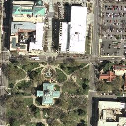
I joked in my column about the stealth black helicopters They have flying all over the place, but you can see the cars in the above shot of the old N.C. Capitol.
You can also try terraserver.microsoft.com/ or geography.usgs.gov/partners/viewonline.html for maps and stuff.
There�s always www.mapquest.com and one of my favorites (GREAT graphic capability) is www.us.map24.com/, which has a function that lets you map a route avoiding major roads - useful for cycling.
Enjoy, take care, stay safe.


1 Comments:
Thanks!
Post a Comment
<< Home